Learning Cartography; or, a Gallery of Awesome Maps

If you were to stand outside the castle-like red brick building that is the University of Wisconsin–Madison’s Science Hall late at night and towards the end of the semester, you wouldn’t be able to tell that the windowless third-and-a-half floor computer lab is abuzz with activity. It smells like printer ink, sweat, and Jimmy John’s delivery as Introduction to Cartography students are finishing up their final projects. Varying states of frenzy ensue. Shoes may or may not be on. One student may or may not be wearing fox pajamas.
Introduction to Cartography is in some ways a misnomer: students start out with little to no background in map design, but by the end of the semester they are making professional quality, award-winning static maps and cultivating unique and creative styles. The class culminates in a final project of creating a map of their choice. As each student tackles an individual project, we, the instructors, tackle 40 projects and remain on call for data crises, lost flash drives, brain picking, and feedback on last-minute layout changes. Simultaneously exhausted and energized by the students and their creativity, we are gushing fans as they submit their final drafts to our mailboxes.
From a typographic map in Chinese to multivariate maps of crime and inequality in the Midwest, this exhibit displays fresh perspectives on space(s) and place(s). One map shows a mapmaker’s intimate connection to her family’s farmland, visually depicting her place-based memories. Another repaints the Silk Road and ominous sea monsters in a new light. Several reveal what one student calls “landscapes of discrimination,” visualizing racial differences in access to housing, education, and wealth.
We hope you enjoy this selection of student maps from the Fall 2015 semester. The rest await your further exploration in the Robinson Map Library and the third floor wall gallery in Science Hall.


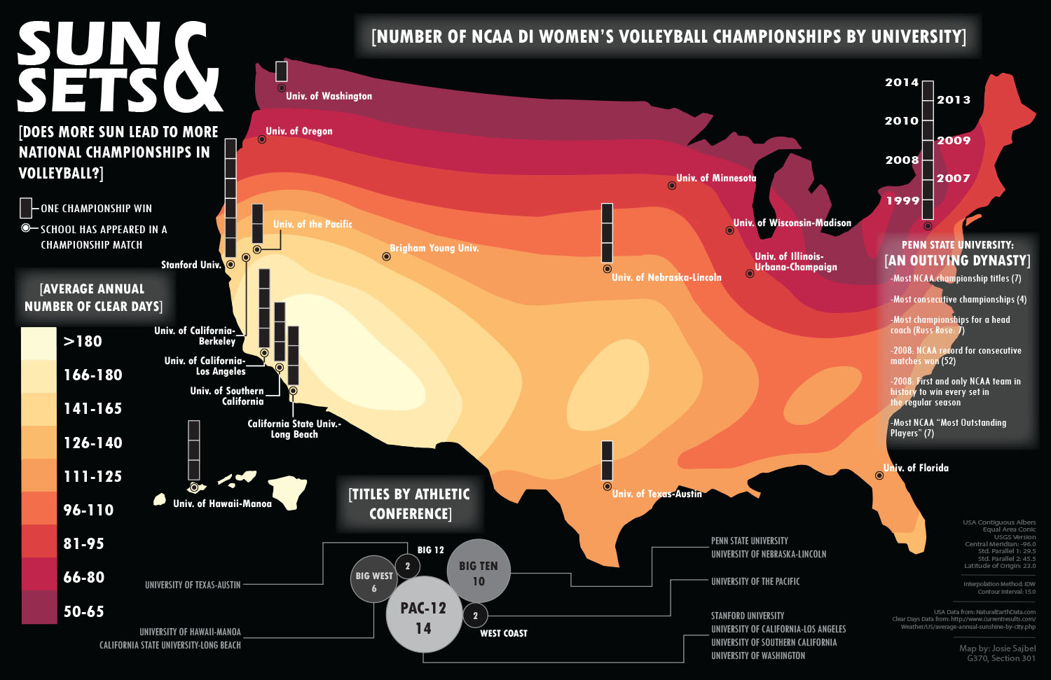


Featured Image: Sun and Sets, map by Josie Sajbel.
Heather Rosenfeld is a geography graduate student at the University of Wisconsin–Madison and part-time instructor at Madison Area Technical College. Her research interests include human-nonhuman relations, alternative economies, technology and environmental justice, and feminism in the academy. She is currently working on a dissertation on farm animal sanctuaries, focusing primarily on chickens (who are awesome). She makes comics as part of her research process, and for fun. Twitter. Contact.
Meghan Kelly is a cartographer and graduate student at the University of Wisconsin–Madison in the department of Geography. Her research intersects cartography and human geography. She is specifically interested (at the moment) in critical cartography, borders, and mapping experience. Website. Contact.
Robert Roth is an Assistant Professor of Geography at the University of Wisconsin‒Madison and the Faculty Director of the UW Cartography Lab. Rob researches and teaches cartographic design, interactive and web mapping, and geographic visualization. Twitter. Contact.
Wow, so much awesomeness! Nice job everyone!